Showing posts with label topography. Show all posts

Friday, March 21, 2014

Environmental History and Real Estate

Business Insider SF Real Estate Market Explosion 
It's no secret that San Francisco Real Estate is hot hot hot, and Marin is not far behind in terms of multiple offers well over asking. The bidding war is just part of life now, alas. If you are focused and can afford to compete, I can help get your offer accepted, or if you want to sell I can help you do so smoothly and efficiently. Don't sell with out a good plan in place, as selling is soooo much easier then buying right now. My esteemed colleagues and reporters have covered the changing real estate landscape  very well, so I'll stick to my obsession with earth based real estate.


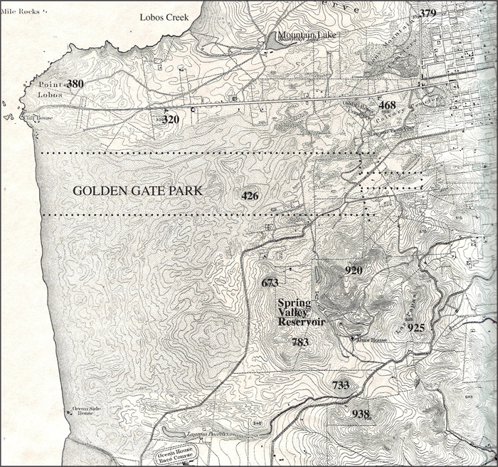
This fabulous article, via Richmond Blog from the wonderful Outside Lands folks, sums up how water shaped the development of the western side of the city. Of course water and topography also shaped the development of the rest of the city and Marin, and historical development across the globe.


Topography has a powerful influence on microclimates, on earthquake risk, tsunami risk, underground creek issues, even how well your plumbing works. Location is the one thing you cannot change when you buy property, and it is easy to forget that the earth is still underneath all this built environment we live in.

So, as you gird your loins to enter the fray, pull focus a little on that property you are so excited about. Will the climate suit you when the dust of the escrow settles? Is it in a landslide or flood zone? Will you be able to grow the things you want to grow, or will you have to spend extra on earthquake or flood insurance? Flood insurance rates are rising fast, but that's for another post.


Bold Italic - Microclimates

If you already own property here, and are staying put but curious, or renting and curious, the San Francisco Library has tips for researching buildings, and Nature in the City put together a wonderful nature map of the city. If you are in the market, though things are moving fast and furiously these days, do be sure review the Natural Hazard Disclosures, to be sure you know about long term environmental realities you may not notice underneath the fresh paint and newly refinished floors.

SF Rec and Park, Nature in the City

Happy Spring!

Friday, March 1, 2013

Mission Creek


I'll be holding open a junior 1 bedroom condo at 888 7th Street on Sunday, 2-4. Since a segment of the Mission Creek Greenway and Bikeway is located on the site, and just for the sake of watershed awareness, I took a look at site on the super cool watershed finder put together by the Oakland Museum. 

Oakland Museum
DeeDee posted this about the new park, under some of which the creek still flows. Here is the big picture to come, and if the freeway actually comes down, wow! The unit I'll be holding open faces the big curve with the mural on the Cal Train tracks. You've gotta like trains, and I do. It's a cool curvaceous industrial view, sparkly at night with the Bay Bridge view. Come by and see me Sunday, and then take a walk in the park.

True Mosaics


Postscript: In chatting with my sister, who works at Adobe, whose SF headquarters is right next door, we got curious about the Baker and Hamilton building.  She came up with this this link, which has lots of fun links, explaining, for example, why the train track curve is there.


Tuesday, December 4, 2012

Maps Are Your Friends


Fern Hill Walking Tours


Curbed SF's  post today about locations of former cemeteries, and other cool posts tagged Cool Map Thing, highlight the usefulness and beauty of maps. When you are searching for your next home, maps can really be your friend, especially historical and topographical maps, which can give you a sense of the environmental and human history of a home site. We often think of the environment as somewhere out there in a national park, but every home site is located within topography and history, space and time. Some history is fun to learn about, some not so much, but better to learn before closing escrow.

Kroll Antique Maps

If you are the curious sort, who likes to muck about with research, and you are in the early stages of your home search, here are some tips from the environmental research field. Libraries in Marin and San Francisco have wonderful collections of old maps, photo's and other archives. The San Francisco Planning Department also has a terrific collection of maps of all sorts, and a quick google image search will pull you down endless fascinating rabbit holes.


Marin Library

If you are busier, farther along and/or not a researching type, fear not, because sellers/listing agents pay a service to prepare a  "real estate natural hazard disclosure" which is included in the disclosure (or buyers) package. JCP and Disclosure Source are commonly used in San Francisco and Marin. These services comb the various maps available, such as the liquefaction hazard map, the FEMA flood map etc, and compile the data specific to the property into the report. Do take the time to read these reports, better to understand the location you are committing to sooner then later.


Friday, May 11, 2012

Macro Microclimate

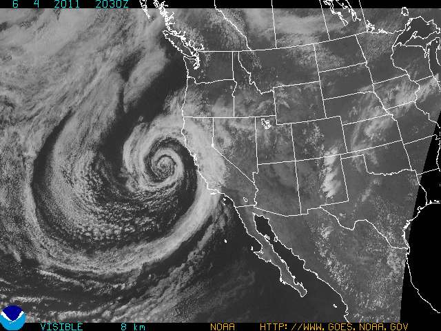
Sometimes it just comes down to foggy at the coast, and clear inland. Simple as that.


Everything more micro is nuance, as the fog, wind and topography do their dance. Happy Friday folks, hope your climate suits you this evening.

Photo via

"This is a Visible Satellite image. Most images you see are Infrared images which use tempertures to create clouds. Visible Satellites just flat out take a photo graph. "


Monday, April 23, 2012

Microclimates and Real Estate Districts

 
People often ask me about the weather in specific areas, so it seems maybe time to start posting about microclimate by real estate zone. Of course, micro climate can be very micro so there will be multiple microclimates in each zone, depending on slope, aspect etc., but some generalizations can be made.

OCSC Sailing School

There are various apps, for Android, and now for iPhone, which draw from the wonderful Weather Underground  weather station data, which can give you more or less present time data on weather in different locations. I love the accuracy of this data- I had an open house out at Ocean Beach on an extremely windy Sunday a while back- the swell was up and there were a bunch of kite surfers out. My weather reports kept saying 10 mph winds, but I was freezing in the foyer and watching the kites rip around and that just did not compute. I finally dug into the Weather Underground app or the weather stations, and sure enough, the Outer Richmond station reported 25-35 mph, with gusts to 45, which made me feel a lot less crazy. 

SanFranciscoWeather


So, you can use Weather Underground weather station data, on your phone or computer, to compare the weather in different zones. As discussed ad nauseum, there are generalities- east is warmer then west, south facing is warmer than north etc.

Acme.com

Notice, above, the three different weather forecasts for inland, bay and coast? If you don't like the weather, you don't have to go very far. Since your home can't move though, it's good to choose a climate you prefer when you are making a purchase. In the next post I will begin to make my way across the real estate maps of the city and Marin and blather on about climate, parks and open space, walkability and the like for each zone or town. In the meantime, here's the "super scientific" (not, but close enough) map from heyneighborhood.blogspot.com for San Francisco, and a cool little write up on Marin microclimates here.


Wednesday, August 24, 2011

Shake-y Shake-y

Standing on Shakey Ground


punkrockmichelle
All kidding aside, it seems like a good time to take a closer look at the Liquefaction map, and the Seismic Hazards Maps.  Prior to purchasing property here, you may want to look at the properties location on the hazard maps, to see if it is located in a liquefaction or landslide zone.  

geoIQ
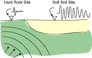
When the earth shakes, the underlying earth material is of differing degrees of "shake-ability". Bedrock is the most stable, though it varies depending what kind of bedrock, and mud and fill are the least stable.


Museumca.org
The liquefaction map looks very similar to creek and watershed maps, which is because much of the liquefaction area is fill, (old ships and garbage) placed in former creeks and wetlands. In these areas, the ground can turn from a solid to a liquid state when shaken, causing increased likelihood of buildings being shifted off their foundations or worse. 


mceK12


The golden gate hills offer up exposed bedrock, or a covering layer of less consolidated rock or soil, and often a mix of the two. The variable substrates can be subject to different types of landslides, which can be triggered by earthquakes, or by high levels of rainfall.


SLU


The extreme variations in damage and death tolls we see with earthquakes, often house by house, have to do with proximity to epicenters and variable substrates but also building codes, materials and practices. For example, Port au Prince Haiti was close to the 7.0 epicenter, with largely unreinforced masonry construction and an enormous death toll, while the recent 8.8 Chilean earthquake killed less than 1,000 people, due to the distance of the epicenter from major population centers, and to building codes.


America's North Shore Journal


Earthquake insurance is expensive and limited here in our earthquake prone locale.  We'll take a closer look at our local earthquake related real estate issues in Shake-y Shake-y Part 2...


USGS


in the meantime, you can check out this cool link to earthquakes round the world.


(Thanks to Judith Sheridan and Zoe Cooper-Caroselli for your insights)

Saturday, June 4, 2011

"Stand in the place where you are, now face north"


OK, now that I've got the tree rant out of my system (for now), this weird November in June weather has me turning to the crux of what I think is most important about property location; the interaction between weather and topography, ie the slope (steepness of terrain) and aspect (orientation - North, South, East, West) of a property relative to our marine influenced Mediterranean climate.
GOES.NOAA.GOV

I will admit, numerous other factors; schools, architecture, walk-ability, density, crime levels, and access to open space and transit, do powerfully affect livability and property values. (Lots of links on the right for more local detail on these subjects.)

My feeling though, is that slope/aspect/climate interactions ultimately trump these (if not actually determining them in the first place) in terms of daily quality of life. Plant life and vernacular architecture all over the world reflect the diversity of these interactions.  Thus I shall begin a series of posts about our many local micro-climates and how they got that way, as soon as I can untangle all the interlocking parts enough to figure out where to start.

http://tornado.sfsu.edu/geosciences/classes/m356/Pastlinks_F2004.html


sanfrancisco.cbslocal.com

Happy November in June!