Showing posts with label environmental hazards. Show all posts

Tuesday, December 4, 2012

Maps Are Your Friends


Fern Hill Walking Tours


Curbed SF's  post today about locations of former cemeteries, and other cool posts tagged Cool Map Thing, highlight the usefulness and beauty of maps. When you are searching for your next home, maps can really be your friend, especially historical and topographical maps, which can give you a sense of the environmental and human history of a home site. We often think of the environment as somewhere out there in a national park, but every home site is located within topography and history, space and time. Some history is fun to learn about, some not so much, but better to learn before closing escrow.

Kroll Antique Maps

If you are the curious sort, who likes to muck about with research, and you are in the early stages of your home search, here are some tips from the environmental research field. Libraries in Marin and San Francisco have wonderful collections of old maps, photo's and other archives. The San Francisco Planning Department also has a terrific collection of maps of all sorts, and a quick google image search will pull you down endless fascinating rabbit holes.


Marin Library

If you are busier, farther along and/or not a researching type, fear not, because sellers/listing agents pay a service to prepare a  "real estate natural hazard disclosure" which is included in the disclosure (or buyers) package. JCP and Disclosure Source are commonly used in San Francisco and Marin. These services comb the various maps available, such as the liquefaction hazard map, the FEMA flood map etc, and compile the data specific to the property into the report. Do take the time to read these reports, better to understand the location you are committing to sooner then later.


Tuesday, January 31, 2012

Natural Hazard Disclosures

Free stock photography

Making an offer or going into contract on a property in California, and especially in San Francisco, your first  major document review will be of the (sometimes an inch thick) property "disclosures".  Some listing agents will request a signed disclosure package be submitted with the offer; in any event the signed document is often due quite early in the contingency period.


Schooner Property
In the rush of putting in an offer, it is easy to skim this dense document without really comprehending what's in it. Fear not! This is one place your agent can really offer value, helping  you to filter the truly property specific information from what is boiler plate legalese, so you'll know what is really important to understand before you commit to a contract and start spending money on inspections. 


Liquefaction Hazard Maps

Of most relevance to this blogger, as your earth based realtor, is the Standardized Natural Hazard Disclosure Report, which details the possible risk of floods, fires, earthquakes, liquifaction, and landslides occurring at the  property. At the risk of sending you to a competitor, here's a link to a nice summary of how to review the Natural Hazards report. When a property is listed, the agent orders this report from one of several companies that search the hazard maps and lists the hazards that are potential issues with that specific property. Also, there is the Combined Hazards Book, which you'll need to review and sign off on during escrow.


Disclosure Booklets

 If you are the kind of person who likes to educate yourself ahead of time, you can look at hazard maps yourself (see links in my past posts re: slope and extreme weather  and also in the resource bar) for the areas you are considering. Ponder your level of comfort with various environmental risks, do a little insurance research, and you'll feel more prepared to make an informed purchase.


Putting Down Roots in Earthquake Country

Wednesday, August 24, 2011

Shake-y Shake-y

Standing on Shakey Ground


punkrockmichelle
All kidding aside, it seems like a good time to take a closer look at the Liquefaction map, and the Seismic Hazards Maps.  Prior to purchasing property here, you may want to look at the properties location on the hazard maps, to see if it is located in a liquefaction or landslide zone.  

geoIQ
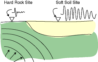
When the earth shakes, the underlying earth material is of differing degrees of "shake-ability". Bedrock is the most stable, though it varies depending what kind of bedrock, and mud and fill are the least stable.


Museumca.org
The liquefaction map looks very similar to creek and watershed maps, which is because much of the liquefaction area is fill, (old ships and garbage) placed in former creeks and wetlands. In these areas, the ground can turn from a solid to a liquid state when shaken, causing increased likelihood of buildings being shifted off their foundations or worse. 


mceK12


The golden gate hills offer up exposed bedrock, or a covering layer of less consolidated rock or soil, and often a mix of the two. The variable substrates can be subject to different types of landslides, which can be triggered by earthquakes, or by high levels of rainfall.


SLU


The extreme variations in damage and death tolls we see with earthquakes, often house by house, have to do with proximity to epicenters and variable substrates but also building codes, materials and practices. For example, Port au Prince Haiti was close to the 7.0 epicenter, with largely unreinforced masonry construction and an enormous death toll, while the recent 8.8 Chilean earthquake killed less than 1,000 people, due to the distance of the epicenter from major population centers, and to building codes.


America's North Shore Journal


Earthquake insurance is expensive and limited here in our earthquake prone locale.  We'll take a closer look at our local earthquake related real estate issues in Shake-y Shake-y Part 2...


USGS


in the meantime, you can check out this cool link to earthquakes round the world.


(Thanks to Judith Sheridan and Zoe Cooper-Caroselli for your insights)