Showing posts with label earthquakes. Show all posts

Wednesday, September 26, 2012

Liquefaction


While on Zephyr tour recently, en route to a new pocket listing in the Arterra, (which a building guy proudly told us was the first LEED certified building in the city) the question of whether we were in the liquefaction zone came up. I looked around and guessed that yes, it was likely, and it got me to wondering how on earth we keep building buildings in the liquefaction zone.


USGS

As discussed here, liquefaction refers to areas of young geologic deposits, and/or fill, in low lying areas, where "soft muds are subject to the phenomenon of saturated soils losing their stiffness and strength during shaking. Young deposits will liquefy, or turn into a sandy liquid due to the strong shaking a big earthquake will produce."

Alex Clark wrote a pretty great post with maps for the Front Steps while back that gives a good sense of liquefaction locations.

The Real Dirt on Liquefaction, has a table: Techniques for Liquefaction Hazard Mitigation on page 20, if you are curious, and of course, the guide below. My curiosity about modern earthquake engineering is not fully slaked, so there will be more on this subject...


Friday, September 2, 2011

Shake-y Shake-y Part 2

OK, now we can turn back to seismic subjects, now that Hurricane Irene has spared my daughter, and the time for earthquake weather is approaching. Though there is little data to support this concept, the especially warm weather that we typically get in September and October often feels a little ominous to me. I guess this is because in my lifetime, both earthquakes and fires have occurred during these periods of stillness or offshore (Diablo- devil) winds that come when the summer fog wall loosens its grip. 


Purdue University
Back to fire danger later. In the context of real estate here and our ongoing bio-geographic risk assessment, the overall message (that most of us have gotten already) is that we live in an earthquake prone locale. "The Bay Area straddles the boundary where two of the Earth’s largest tectonic plates meet and slowly move past one another. When boundary faults break and the North American and Pacific Plates lurch past each other, quakes occur." Most of us have heard of the San Andreas and the Hayward faults, which are the biggies, and there are lots of others. 


KVEC
Earthquake insurance is expensive and limited. Before purchasing property here you'll want to look at the hazard maps for property location. Also look at the foundation and type of construction of the building. Putting Down Roots in Earthquake Country, and the Bay Area Governments Earthquake and Hazards Program are worth a look for sure. 


When you are looking at condo's with high HOA dues, find out what they include. Typically they include building insurance among other things. Sometimes they are high due to earthquake insurance, which some buildings do not carry due to high cost and high deductibles.


USGS


Beware especially the brick foundation. If it has not been seismically retrofited, or replaced, you will want to have an engineering inspection done during your inspection period and get an estimate of what it will cost to bring the building up to code. Some homeowners take the opportunity to add a garage when they do this, which adds quite a bit of value, especially in certain neighborhoods. Parking can be so precious, especially in the city, but also on many steep, narrow, twisty roads in Marin. Of course this requires a permit, and is not cheap


For now though, wishing you all a safe, restful, fun holiday weekend, sans natural disasters!


Allaboutnews


Wednesday, August 24, 2011

Shake-y Shake-y

Standing on Shakey Ground


punkrockmichelle
All kidding aside, it seems like a good time to take a closer look at the Liquefaction map, and the Seismic Hazards Maps.  Prior to purchasing property here, you may want to look at the properties location on the hazard maps, to see if it is located in a liquefaction or landslide zone.  

geoIQ
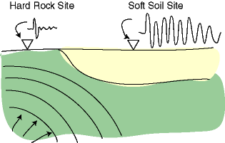
When the earth shakes, the underlying earth material is of differing degrees of "shake-ability". Bedrock is the most stable, though it varies depending what kind of bedrock, and mud and fill are the least stable.


Museumca.org
The liquefaction map looks very similar to creek and watershed maps, which is because much of the liquefaction area is fill, (old ships and garbage) placed in former creeks and wetlands. In these areas, the ground can turn from a solid to a liquid state when shaken, causing increased likelihood of buildings being shifted off their foundations or worse. 


mceK12


The golden gate hills offer up exposed bedrock, or a covering layer of less consolidated rock or soil, and often a mix of the two. The variable substrates can be subject to different types of landslides, which can be triggered by earthquakes, or by high levels of rainfall.


SLU


The extreme variations in damage and death tolls we see with earthquakes, often house by house, have to do with proximity to epicenters and variable substrates but also building codes, materials and practices. For example, Port au Prince Haiti was close to the 7.0 epicenter, with largely unreinforced masonry construction and an enormous death toll, while the recent 8.8 Chilean earthquake killed less than 1,000 people, due to the distance of the epicenter from major population centers, and to building codes.


America's North Shore Journal


Earthquake insurance is expensive and limited here in our earthquake prone locale.  We'll take a closer look at our local earthquake related real estate issues in Shake-y Shake-y Part 2...


USGS


in the meantime, you can check out this cool link to earthquakes round the world.


(Thanks to Judith Sheridan and Zoe Cooper-Caroselli for your insights)