Showing posts with label GGNRA. Show all posts

Monday, June 4, 2012

Park Score, Chirp Score*

RolandNikles
The Trust for Public Lands recently introduced Parkscore, "with detailed profiles and interactive maps, ParkScore makes it easy to explore and compare city park systems from around the country"


Glen Canyon Park, SF
San Francisco ranked highest! Yet another reason it is wonderful to live here. Since this ranking system measures cities, Marin is not measured under Parkscore, but depending on who you listen too, the county is 50 to 90% open space, more than any other county in the SF Bay Area.


Quality of life (health, ability to concentrate, etc) is so much higher when there is somewhere green to enjoy,  especially when you are also within walking, biking or a quick driving distance of the wonderful cultural amenities, and job opportunities, here.

*Thanks to Stacy Lamirand for "Chirp Score"


Tuesday, May 1, 2012

Microclimate - Outer Richmond

cocoi_m's photo stream
As promised, "microclimate by real estate zone" posts hereby begin. Here is the real estate zone map, via the 
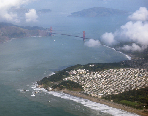
Zephyr site, where you can see that Zone 1E is the in the far northwest corner of the city, extending west of 32nd Avenue out to Ocean Beach. It is surrounded by parks (GGNRA's Lands End to the north, and Golden Gate Park to the south) and ocean on three sides. 1E is one of the coolest parts of the city, temperature-wise, with fog often moving in from the beach, and pouring in the Golden Gate.

SFGate

The spring winds from the northwest hit this area first, and sometimes with the most force, because the wind accelerates when it finds the gap of the Gate, so both the north coast and Ocean Beach sides get plenty of wind. The new Lands End Lookout is brilliantly oriented with its back to the wind, which creates a wonderfully sheltered outdoor space in the lee of the building, and on days like today you can enjoy the awesome views from your cozy spot inside.


SFVA

There are some areas that are more sheltered than others, such as the coveted blocks of Sutro Heights, near Sutro Heights Park (below) on the south facing hillside below the far west end of Geary. Washington High School is at the top of the other large hill in the district, there are some warmer pockets east and south of there, and on each block there are more or less sheltered areas. Here is the Kelly's Cove weather station, for your use, should you be sweating in the Mission and thinking about the beach. Today's 33 mph winds probably nixed that idea. Kite surfers were happy though.

Poetic Shutterbug

If you are a heat lover, you may not be happy in the Outer Richmond. If you like it cool and fresh and quiet, with seagull sounds and salty air, and appreciate good food and a fun theater, 1E is for you. If you are park and ocean minded, you will love it. Many winter days are lovely, with sparkling clear skies, and less wind than in the spring. In the summer, the fog and sun dance can be very entertaining, and the fall, well, it's pretty heavenly.

Monday, December 12, 2011

Hikeability, Marin and SF

A friend involved with trails planning at the Presidio Trust recently took me on some new connector trails in the Presidio. Wonderful to explore some new access routes to places I have been circling around for years.

Presidio Trail

We are so blessed here with great places to walk/hike. Here's a great place to start if you want to hike in the Golden Gate National Recreation Area.  Also, the Presidio Trust, and San Francisco City Parks  (Golden Gate Park, McClaren Park etc) have many lovely trails, not to mention gardens for your walking pleasure.
Strybing Arboretum
In Marin we have the wonderful Point Reyes National Seashore, and Marin County Parks and Open Space,
Marin Municiple Water District  as well as Samuel P.Taylor, China Camp and Mt Tamalpais State Parks. For Marin I highly recommend the Tom Harrison maps, during my vegetation mapping days I found them the most accurate and easy to use, and they cover all the parks/wildlands in a given area. They are available at many park visitor centers, and online at Toms site. Alas, due to budget restrictions, the State Parks are subject to closures, so check the website for specific parks before you head out.

Tom Harrison Topo Map
What does this have to do with real estate?  Property near hiking trails is of high value, because people love to breath the fresh air and absorb the soul solace that nature provides. Contact with nature is good for our health and attention spans, and we are truly blessed here with so many parks and wildlands so close to our world class city. Many thanks are due to the persevering people who made sure these lands were protected. and that's a matter for later post...

Saturday, September 24, 2011

Fire on the Mountain

Though I am rather a glass full and overflowing kind of gal, I am noticing that the topics that come to me here are rather gloom doomish. If you have seen a local disclosure package, you'll know it is quite lengthy, and if you actually read it all, you may worry that owning property here at the golden gate is fraught with peril. 

OHExpress

Fortunately, any given property is unlikely to be subject to all of the perils outlined in disclosure packages, and if you take the time to educate yourself (and /or have a great realtor) ahead of time, you can avoid or ameliorate problematic issues, or at least choose which risks to take. 

JDubrasky Hazard Disclosures

Hiking on the mountain and smelling the chemise and coyote brush reminds me that we are now in the fire season for our area, so today's subject is choosing real estate with fire in mind.

NPS.gov
The WUI zone is where structures and other "human development meet and intermingle with undeveloped wildland or vegetative fuels." In other words, houses surrounded by wildland plant life.


NIST
Though I am a plant nerd, and love the feeling of luxuriant vegetation, in our mediterranean climate, where we get little to no rain during the summer, vegetation dries out and becomes tinder by September/ October, just waiting for a spark to set it off.  On the coast the fog keeps things moist, so the fire prone areas are more inland in the hotter locations such as Novato and the eastern slopes of Mt. Tam. 

DreamNotof Today
Much of Marin's wonderfulness is due to the fact that almost anywhere in the county you can walk to open space of some kind: Marin County Open Space, Marin Municiple Water District, Mt. Tam State Park, Point Reyes National Seashore, Golden Gate National Recreation Area


Marin County
Since much of these open space area's contain fire dependent vegetation, fire is a natural part of life in these area's. Property ownership within these plant communities comes with the likelihood of fire at some point. As people have increasingly moved into fire prone areas, fire protection costs have become prohibitive. Here's info about the new state fire protection fee


Firewise


While defensible space is key to protecting your property in a WUI zone, it is good to consider location first and foremost. Understanding basic fire behavior is important if you are looking at property adjacent to fire prone wildlands. 

hphanson
Moving into a high fire danger location, and then mowing down all the vegetation that makes the place magical in the first place, may not be the most practical (not to mention ecological) approach. In certain locations, defensible space will not protect you. Personally, I would especially avoid owning property at the top of a narrow or box canyon, in chaparral, no matter how gorgeous the views. If you insist, maybe build your house with stone, steel, or concrete.